
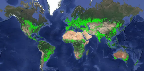
India has the world’s largest cropland
A new US Geological Survey map shows the country with the most croplands in the world and it is neither US nor China but India.
Global cropland totals 1.87 billion hectares (4.62 billion acres), more than 15 per cent higher than earlier estimates according the map released by the US Geological survey.
India has the largest cropland of any country at 179.8 million hectares compared with 167.8 million in the US and 165.2 million in China.
South Asia and Europe can be considered agricultural capitals of the world due to the percentage of croplands of the total geographic area. Croplands make up over 80 per cent of Moldovia San Marino and Hungry between 70 and 80 per cent of Denmark. Ukraine, Ireland and Bangladesh and 60 to 70 per cent of the Netherlands, United Kingdom, Spain, Lithuania, Poland, Gaza Strip, Czech Republic, Italy and India. The US and China each have 18 per cent croplands.
The study was led by the USGS and is part of the global food security support analysis data @ 30-m (GFSAD30) Project.
With the global population nearing the 7.6 billion mark and expected to reach 10 billion by 2050, it is of increasing importance to understand and monitor the state of agriculture across the world in in depth detail.