
Super Typhoon Soudelor heading towards Taiwan, Japan and China
Super Typhoon Soudelor is heading towards Taiwan, Japan and China after leaving a trail of destruction in the Northern Marianas islands.
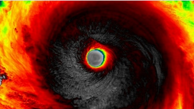
The cyclone has developed into the world’s most powerful storm of the year with wind gusts up to 220mph (354kph) that have ripped down telegraph poles and flipped over cars. A state of emergency has been declared on the islands where over 400 residents are sheltered in emergency accommodation. The Category 5 storm is expected to strengthen further with sustained speeds of 150 knots 172.62mph, 277.8kmph, later on 4th August 2015 according to according to US space agency NASA. The joint Typhoon warning centre is predicting wind speed could reach 160 knots with gusts reaching 195knots 224 mph, 361kph.
The big storm may boost El Nino, in the central and Eastern pacific. El Nino are marked by the reversal of the easterly trade winds blowing along the equator. The heat tends to build up in the central and eastern pacific shifting the rainfall patterns eastwards away from the Australian continent and south-east Asia. El Nino is an anomalous and periodic warming of the central and Eastern equatorial, pacific ocean, every 2-7 years, this ocean warms for 6 to 18 months. Thunderstorms require at least some degree of warm humid air near the surface, so they are more numerous and persistent over the western pacific warm pool and much less so in the eastern equatorial pacific. During an El Nino, these trade winds weaken, and reverse from West to east. Warmer pacific water then slowly spills back toward the central and even eastern pacific ocean – the equatorial trapped Kelvin wave. So the most persistent Thunderstorms will shift from the western to the eastern and central pacific ocean in an El Nino. The season started with stormy start with 13 cyclones, typhoons tropical depressions in the western pacific and 10 such storms in the Eastern pacific.
Thirty feet ( 9 meters) high wave hit the island of Saipan and is forecast to surge West-northwest over the western pacific ocean during the next few days where it will weaken before hitting Taiwan over the weekend.